We are pleased to release detailed terrain information for all 4000+ big game units that we currently cover. These additional numbers will give all of our PEAK members another set of unique and industry best data to use when researching for your next big hunt.
This terrain information is the result of a comprehensive analysis of the USGS 1/3 arc-second National Elevation Dataset. The 1/3 arc-second data provides complete coverage of the lower 48 with elevation data points approximately every 10 meters across the entire landscape.
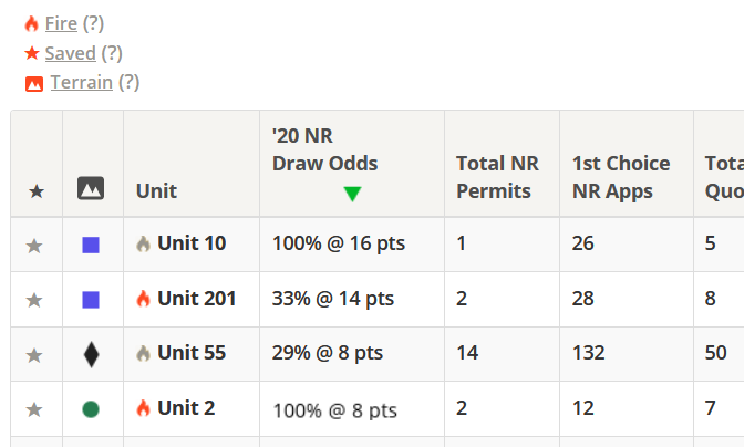
The terrain information for every individual unit includes:
- Average slope angle (steepness)
- Percentage of terrain with extreme slope
- Average elevation
- Highest elevation
- Lowest elevation
- Distribution of elevation (in 1000 ft increments)
In addition, you can view all of this unit specific terrain data segmented into these 5 categories:
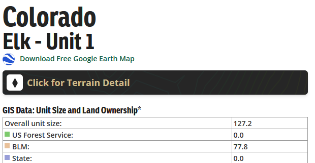
- Unit Wide
- All Public Land (default)
- US Forest Service only
- BLM only
- State only
We segmented our results in this manner for 2 reasons. One, we often know which type of public land we will be spending most of our time on for a given hunt. And two, in certain areas of the west there can be significant differences in terrain characteristics given large blocks of public land managed by a particular agency. For example, Forest Service land may be more mountainous than BLM on average. Having more specificity in this manner can help you get a better feel for the terrain in which you anticipate hunting the most.
Segmenting and analyzing the data in this way was a bit of a challenge given the complexity of public land boundaries. Elevation data is typically contained in raster files where each individual pixel in the file contains information about the elevation of that point on the surface. In order to get the segmented results it was necessary to "clip" each elevation raster tile by public land boundary type prior to performing the analysis. For example, a raster file image clipped from BLM boundaries might result in something like this:

With the non-BLM portions of the elevation data now "blacked out", we can begin to compute our averages and totals as we crawl across the landscape point by point. And because big game unit boundaries can span across multiple individual elevation files, it becomes necessary to systematically stitch together individual tile totals (by land type) in order to achieve the desired end result.
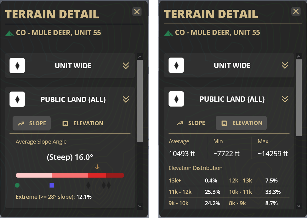
Slope angle is a measure of steepness and it is important to have a frame of reference when determining what "steep" is. A flight of stairs usually has a slope angle somewhere around 30 - 33 degrees. You might be thinking that most staircases don't really seem that steep. But a better way to visualize the steepness of a staircase is to look at the handrail. A 30 degree slope angle is extremely steep when you don't have nice flat steps to increment your way up or down!
When calibrating steepness, averages over large sections of land tend to settle on slope angles that may not seem that impressive at first glance. If you are standing on a 15 degree slope it may not seem steep at all, but having an average of 15 degree slope over a few hundred square miles means a different thing in aggregate.
Because we processed and measured all of the units in the exact same manner, we can begin to draw some meaningful conclusions when researching and comparing. After processing the elevation of over 4000 big game units, this is the scale that we use to represent the overall steepness of hunt units:
 More Flat (up to 8.25° slope angle)
 Moderate (> 8.25° slope angle)
 Steep (> 13.5° slope angle)
 Very Steep (> 17.5° slope angle)